


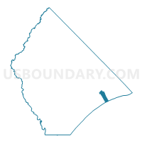
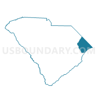
Cresent Voting District, Horry County, South Carolina
About
Outline

Summary
| Unique Area Identifier | 666083 |
| Name | Cresent Voting District |
| County | Horry County |
| State | South Carolina |
| Area (square miles) | 6.12 |
| Land Area (square miles) | 1.87 |
| Water Area (square miles) | 4.25 |
| % of Land Area | 30.51 |
| % of Water Area | 69.49 |
| Latitude of the Internal Point | 33.80658510 |
| Longtitude of the Internal Point | -78.70127850 |
Maps

Graphs
Select a template below for downloading or customizing gragh for Cresent Voting District, Horry County, South Carolina


Neighbors
Neighoring Voting District (by Name) Neighboring Voting District on the Map
- Atlantic Beach Voting District, Horry County, SC
- Ocean Drive 1 Voting District, Horry County, SC
- Wampee Voting District, Horry County, SC
- Windy Hill 1 Voting District, Horry County, SC
Top 10 Neighboring County Subdivision (by Population) Neighboring County Subdivision on the Map
Top 10 Neighboring Place (by Population) Neighboring Place on the Map
Top 10 Neighboring Unified School District (by Population) Neighboring Unified School District on the Map
Top 10 Neighboring State Legislative District Lower Chamber (by Population) Neighboring State Legislative District Lower Chamber on the Map
Top 10 Neighboring State Legislative District Upper Chamber (by Population) Neighboring State Legislative District Upper Chamber on the Map
Top 10 Neighboring 111th Congressional District (by Population) Neighboring 111th Congressional District on the Map
Top 10 Neighboring Census Tract (by Population) Neighboring Census Tract on the Map
- Census Tract 404, Horry County, SC (3,546)
- Census Tract 405, Horry County, SC (3,519)
- Census Tract 603.03, Horry County, SC (1,599)
- Census Tract 9901, Horry County, SC (0)